 Loading...
|
On this page
Work information
Title: Macroscopic Simulation Analysis of Nitrogen and Phosphorus Loss Patterns Category: Project Type: Innovation Training / Agricultural NPS Pollution Focus: Agricultural non-point source pollution, watershed simulation, geographic information systems, machine learning Role: Core member At a glance
Zeng Zhun Geodatabase, LOADEST, InVEST NDR, MixSIAR, Borselli K connectivity index, machine learning, GIS 2024 Quick links
|
Macroscopic Simulation Analysis of Nitrogen and Phosphorus Loss PatternsA 'source-flow-sink' multi-model framework for assessing agricultural non-point source pollution risk. 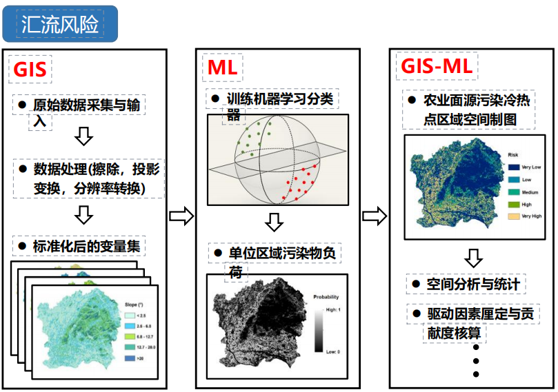
Overview
The project develops a 'plot-watershed-model' analysis route for agricultural non-point source pollution and organizes plot monitoring, watershed transport, and regional risk identification through a 'source-flow-sink' framework. It links field observations of nitrogen and phosphorus loss from rice, maize, vegetables, and citrus plots with process-oriented models and GIS analysis, seeking to connect pollutant generation, hydrological transport, and accumulation-risk areas across scales. Monitoring data and database
The monitoring design integrates water-quality sensors, a Parshall flume, radar flow measurement, an agrometeorological station, and IoT transmission to collect concentration, runoff, and environmental data. Nitrogen and phosphorus are distinguished by form to support load estimation and subsequent source attribution. A Geodatabase is used to organize plot attributes, monitoring records, topography, land use, soil, hydrology, and model outputs, providing a consistent spatial-data foundation for cross-scale analysis. Source: load estimation and pollution tracing
LOADEST is used to relate discrete water-quality samples to continuous flow records and estimate nitrogen and phosphorus export loads for different crop and management conditions. Stable-isotope evidence and the MixSIAR Bayesian mixing model are incorporated to estimate the relative contributions of potential pollution sources, linking total export with source composition. Flow: hydrological connectivity and transport
At the watershed scale, the InVEST Nutrient Delivery Ratio model provides a base representation of nutrient export and retention. Multidirectional flow analysis is introduced to better describe overland transport beyond a single-flow-direction assumption. The Borselli K connectivity index is used to characterize the connection between pollutant-source areas and receiving water bodies, supporting the identification of transport corridors and spatial differences in delivery efficiency. Sink: machine-learning risk identification
Positive and negative samples are constructed from monitoring and spatial evidence, while terrain, land use, soil, climate, and connectivity variables are assembled as model features. Machine-learning classification is then combined with GIS to map areas with higher potential for non-point source pollution accumulation or export. Spatial validation and hotspot inspection are used to check the stability and geographic plausibility of the risk results, forming a regional assessment layer that can support differentiated monitoring and management. Results
The university-level innovation training project completed its scheduled final review. The related work received a bronze award at the 2024 South China Agricultural University Maker Cup Innovation and Entrepreneurship Competition. |