Guangzhou time:Loading...
News Loading updates...
About

I am an undergraduate student in Geographic Information Science at the College of Natural Resources and Environment, South China Agricultural University, under the supervision of Associate Professor Weixing Xue.

Influenced by my advisor's research, my recent work focuses on indoor positioning technologies in surveying and mapping, where I have built substantial research experience.

I also have a solid foundation in geography, with hands-on skills in GIS and remote sensing (RS). I am keenly interested in physical geography, geographic information systems, and interdisciplinary research directions going forward.

Online profiles
ORCID GitHub
Selected publications

An accurate smartphone-based step-counting algorithm based on human walking acceleration variation patterns

Expert Systems with Applications · 2027 · Article number 133800

Co-first author · CAS Tier 1 Top (2025) · Xinkui Tier 1 Top (2026) · JCR Q1 (2026) · DOI

A smartphone-based step-counting algorithm for indoor PDR that uses human walking acceleration variation patterns to reduce missed and false counts during variable-speed walking and start-stop scenarios.

Enhanced Indoor Scene Recognition and Localization for Pedestrian Using Minimum Matching Group of Pedestrian Steps

IEEE Transactions on Instrumentation and Measurement, 2026

Fourth author

A paper proposing an indoor scene recognition and localization framework based on the Minimum Matching Group of Pedestrian Steps (MMG-PS), with multi-source sensor fusion and scene-aware AP selection evaluated across several indoor environments.

Selected projects
Building-obstacle model for UAV 3D path planning

Multi-Layer Raster Coupling with Directional Constraint Coding: A Discrete Spatial Modeling Method for UAV 3D Path Planning

ESRI Cup / GIS Algorithm Design

A discrete spatial modeling method using directional constraint coding and multi-layer raster coupling for urban low-altitude UAV 3D path planning, winning first prize in the Geographic Design track of the ESRI China National GIS Software Development Competition.

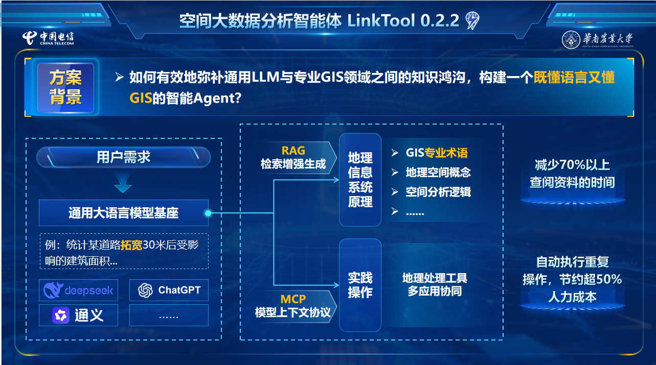
LinkTool spatial big-data analysis agent architecture

LinkTool v1.0 — A Natural-Language-Driven GIS Analysis Agent Based on the Model Context Protocol

GIS Agent / MCP Plugin

An ArcGIS Pro agent-plugin prototype based on large language models and the MCP protocol, exploring natural-language access to commonly used spatial-analysis tools.

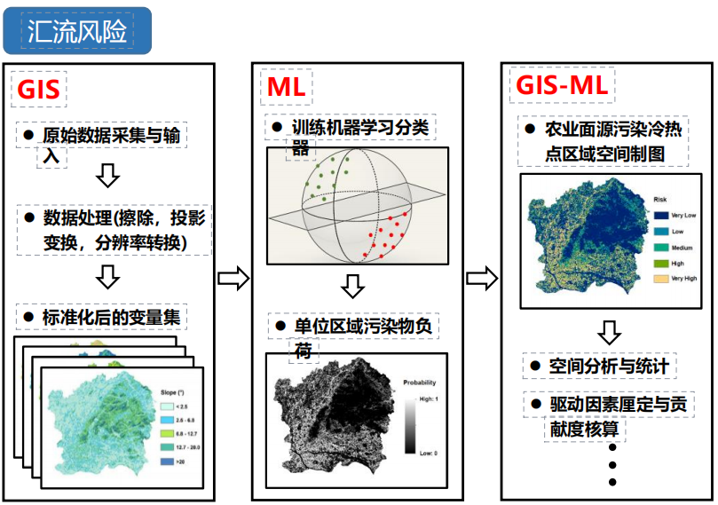
GIS and machine-learning workflow for agricultural non-point source pollution risk

Macroscopic Simulation Analysis of Nitrogen and Phosphorus Loss Patterns

Innovation Training / Agricultural NPS Pollution

A university-level innovation training project exploring a 'plot-watershed-model' analysis approach that combines LOADEST, InVEST, machine learning, and GIS for agricultural non-point source pollution risk assessment.

More work

Village-Scale Reality 3D Modeling with UAV Photogrammetry — A Case Study of Beigen Village, Zhaoqing

Geographic information engineering fieldwork / Digital village

A reality 3D model and village geodatabase created from UAV oblique and nadir imagery, road and POI field surveys, and GIS processing for village visualization and spatial analysis.

Accurate Step Counting and Real-Time Step Length Estimation Based on Pedestrian Single-Step Acceleration Area Features

Surveying and Mapping Competition / Scientific Paper Track

A 2026 Scientific Paper Track study that uses single-step acceleration area features for both step detection and step-length estimation, providing gait-event and per-step displacement estimates for smartphone PDR.

Education for a Rising Bay Area — A Spatial Study of Education through the Development Story of the Greater Bay Area

ESRI Cup / Story Map

A story-map project linking individual education experiences with multi-source spatial data to examine school siting and educational-resource allocation across the Guangdong–Hong Kong–Macao Greater Bay Area.

Reducing Carbon, Enhancing Aroma — Circular Farming and Intelligent Pest Regulation for Zijin Cicada Tea

Challenge Cup and Energy Conservation & Emission Reduction Competition / Low-carbon agriculture

A proposed system combining waste co-composting, intelligent leafhopper monitoring, and pest-informed fertilization, with image recognition and GIS used to assess low-carbon production pathways for Zijin cicada tea.

Reflections of Didou — Revitalizing an Old Cinema as a Township Living Room

Challenge Cup / Rural renewal and cultural-tourism planning

A renewal proposal for an old cinema in Didou Town that preserves its historic character and plans spaces for meetings, exhibitions, fitness, heritage experiences, and local-product promotion.