 Loading...
|
On this page
Work information
Title: Multi-Layer Raster Coupling with Directional Constraint Coding: A Discrete Spatial Modeling Method for UAV 3D Path Planning Category: Project Type: ESRI Cup / GIS Algorithm Design Focus: UAV path planning, 3D spatial modeling, GIS algorithms, raster networks Role: Team lead At a glance
Zeng Zhun Multi-layer directional coding raster, improved D8 rules, 3D A* algorithm, dynamic weight optimization 2025 Quick links
|
Multi-Layer Raster Coupling with Directional Constraint Coding: A Discrete Spatial Modeling Method for UAV 3D Path PlanningUsing directional constraint coding and multi-layer raster coupling to transform continuous airspace into a computable model for UAV 3D path planning. 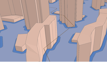
Overview
Addressing the difficulty of traditional methods in quantifying airspace passage rules and the lack of dynamic height-dimensional constraints in urban low-altitude UAV 3D path planning, this study proposes a discrete spatial modeling method based on directional constraint coding and multi-layer raster coupling. Using the Huaqiangbei area of Futian District, Shenzhen, as a test site, the workflow transforms continuous airspace into a multi-layer raster network with directional passage constraints and generates Z-aware 3D routes for visualization and inspection in an ArcGIS Pro local scene. Data processing and spatial discretization
Building footprints and heights are combined with DEM tiles N22E113 and N22E114 to estimate absolute obstacle elevations. A 5 m safety buffer is applied around buildings before the start and destination coordinates are introduced into the analysis extent. The horizontal plane is discretized into 1 m cells and the airspace is sliced vertically at 5 m intervals. Each elevation layer is binarized into a flight-suitability raster, after which directional rasters are computed in batches so that multiple two-dimensional slices approximate the three-dimensional airspace topology. The directional encoding is inspired by the D8 flow-direction rule used in GIS hydrological analysis. The algorithm traverses cells in each layer and encodes every permitted direction combination as a raster value; for example, a value of 239 indicates that all directions except west are available. 3D path search and weighting strategy
The 3D A* search supports 14 movement types: eight horizontal directions, two vertical directions, and four oblique elevation-changing directions. This extends a two-dimensional raster neighborhood into a traversable three-dimensional network while retaining explicit directional constraints. A weighted Manhattan heuristic is used, with a default heuristic weight of 1.5. The search converges when the route reaches within three horizontal cells and 10 m vertically of the destination, and the final node sequence is converted into a Z-aware 3D polyline. Both unweighted and weighted modes are retained. The weighted strategy incorporates turning and elevation-change costs so that path length, excessive heading changes, and unnecessary climbs or descents can be balanced for different route preferences. Case validation and scope
The route is checked against the building-obstacle model in an ArcGIS Pro local scene, allowing the team to inspect whether the generated polyline avoids obstacles and whether the vertical transitions are coherent. The current prototype focuses on static urban obstacles. No-fly zones, vehicle-specific performance constraints, dynamic weather, and multi-target planning have not yet been integrated, so the method is presented as a discrete modeling and algorithm prototype rather than a deployable flight-control system. Competition results
The project won first prize in the Geographic Design track of the 2025 ESRI China National University GIS Software Development Competition, ranking in the top 1.4% of entries. |